A University of Calgary professor has been honoured with a prestigious national research award for his groundbreaking work on a revolutionary 3D digital mapping system developed right here in Canada.
Pioneering Research Earns National Recognition
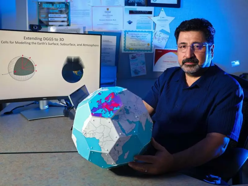
Professor Faramarz Samavati, a PhD in mathematics and computer science, has received the Mitacs Innovation Award for Outstanding Research Leadership. The award, announced in November 2025, recognizes his more than two decades of research innovation, including fifteen years of foundational work on the Discrete Global Grid System (DGGS).
Samavati has been collaborating with students, colleagues, research assistants, and industry professionals throughout his career. He is now working with Calgary-based startup BigGeo to commercialize this transformative technology.

Revolutionizing How We See Our World
The core innovation addresses fundamental limitations of current 2D Geographic Information Systems like Google Maps. "Everything is easier on a plane, but that flattening the map always creates distortions," Samavati explained. These distortions are particularly problematic near the north and south poles, significantly affecting countries like Canada.
His solution involves creating a curved surface model that dramatically improves accuracy. "The main idea is we discretize the surface of the Earth into very uniform cells, like a quilt on the globe," Samavati described. "Each of these cells can be divided into smaller cells—children cells—and this can be done as much as we need."
Transforming Data Organization Across Industries
The system extends beyond surface mapping into true three-dimensional representation. "I extended that to 3D—so rather than just looking at the surface of the Earth, I look at the Earth as a volume, as a 3D object," Samavati said. The grid reaches into the atmosphere to collect climate and weather data while also delving underground for information on pipelines and reservoirs.
Each cell in the system receives a numeric label similar to a coordinate. Location-based data from satellites, drones, and smartphones can then be attached to each cell within the system's database. This provides an elegant mathematical framework to organize what Samavati estimates to be approximately 800 petabytes of location-based data currently in existence.
The technology promises to benefit any industry relying on geospatial information, offering unprecedented accuracy and organization for the massive amounts of location data generated worldwide. "It's a nice, mathematically elegant system to capture everything in a consistent manner," Samavati concluded.