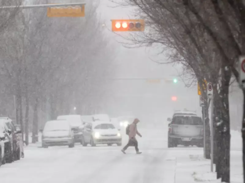
Calgary Braces for Significant Snowfall Event Starting Wednesday Afternoon
Environment Canada has issued a formal snowfall warning for the Calgary region, with heavy precipitation expected to begin Wednesday afternoon and continue through Thursday. Meteorologists project total accumulations between 15 and 30 centimeters, creating potentially hazardous travel conditions across the city.
Precipitation Transition from Rain to Snow
Terri Lang, a meteorologist with Environment and Climate Change Canada, explained the expected weather pattern: "This afternoon, we'll start to see the precipitation move in, and that will probably start in the form of rain, and then switch over sometime in the afternoon towards snow."
Lang noted that during this transition period, residents can expect "really big flakes — really juicy, lots of moisture in them" as the system develops.

Timing and Intensity of Snowfall
The heaviest snowfall is forecast for late afternoon and early evening on Wednesday, with lighter snow continuing overnight into Thursday. Lang warned that temperatures will drop overnight, causing any initial melting to freeze and creating additional accumulation challenges.
"Of course, the temperature will drop overnight, so any initial melting that happens will stop, freeze up, and things will really start accumulating after that," Lang stated.
Consistent Snowfall Across the City
Unlike recent snowfall events that affected specific areas unevenly, this weather system is expected to deliver relatively consistent amounts across Calgary. Lang described it as "a more organized system — what we call a synoptic weather system. It's a low-pressure system. I think everybody's going to be getting in on the fun this time around."
Travel Conditions and Safety Concerns
Environment Canada warns that travel may become challenging due to poor visibility and rapidly changing road conditions. Drivers should prepare for:
- Reduced visibility during peak snowfall periods
- Potentially slippery road surfaces as rain transitions to snow
- Accumulating snow that may affect evening and morning commutes
- Possible freezing of wet surfaces overnight
Spring Weather Patterns in Southern Alberta
Lang explained that these dramatic swings between warm spring weather and heavy snowfall are characteristic of April in southern Alberta. "You've got the mountains there that play a role in where the weather systems go, plus, we still have the colder air lurking to the north, but the warmer air is trying to come up from the south," she said.
The meteorologist further elaborated on the meteorological dynamics: "It's that clash of that cold air and the warmer air to the south that causes these weather systems, and because warm air can hold more moisture, that's why we tend to get the heaviest snowfalls in the spring and in the fall."
April's Volatile Weather History
April ranks as Calgary's second snowiest month, closely following March, though it typically includes some rainfall as well. Lang characterized April as "actually quite a volatile month for weather" in the region, noting that "all the seasons are represented through the spring in southern Alberta."
Residents are advised to monitor updated forecasts from Environment Canada and prepare for winter driving conditions despite the spring season. The snowfall warning remains in effect as the low-pressure system approaches the Calgary area.