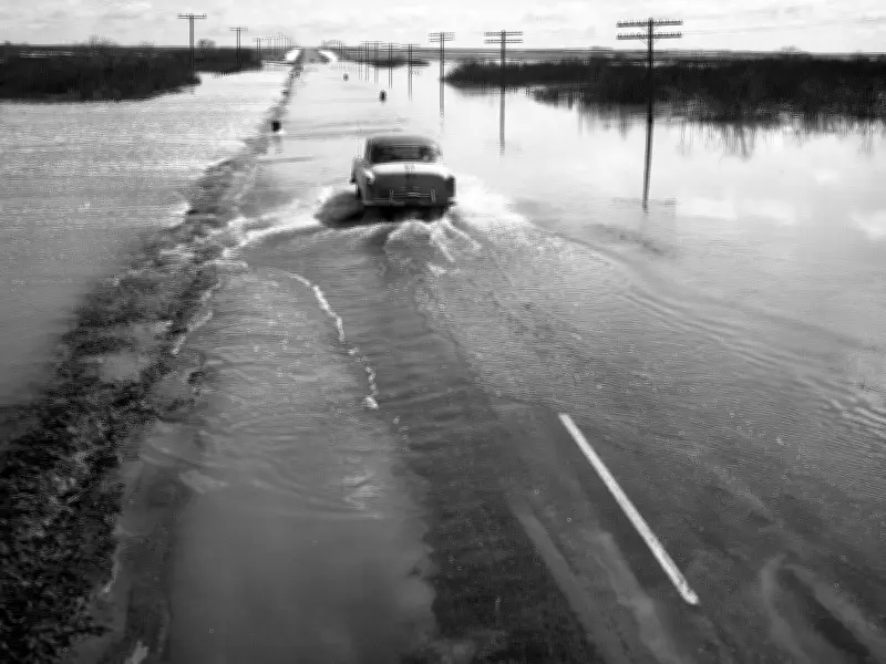
Every Thursday, the StarPhoenix archives, curated by the City of Saskatoon Archives, bring a historical image to light. Today, we revisit April 23, 1956, when flooding on Highway 14 near Eagle Creek made headlines. Despite the road being marked as closed, motorists continued to pass through with caution, as captured in the City of Saskatoon Archives StarPhoenix Collection S-SP-B190-6.
Flooding Across the Province
In 1956, highways across Saskatchewan experienced significant flooding as snow melted. Some roads were closed to traffic while they dried. Flooding streams and sloughs throughout central and northern Saskatchewan appeared to be leveling off and, in some cases, receding over the weekend, according to reports from that time.
Railroad and Highway Officials' Outlook
Railroad and highway officials stated that road and rail grade conditions should show marked improvement within a week, barring heavy rains or another snowstorm—always a possibility in spring. Eagle Creek, which spilled over its banks early Friday and inundated Highway 14 to a depth of more than eight inches for a 300-yard stretch, was receding.

Trouble Spots and Passable Routes
At Lumsden, 10 inches of water from the flooding Qu'Appelle River still covered the grade on Highway 11, but the highway was passable. Many highways were drying up normally, but some trouble spots remained. The area west and north of Biggar was waterlogged, with Highway 14 west and Highway 51 between Biggar and Kerrobert impassable. However, it was possible to reach Kerrobert via Highway 31 from Rosetown. Highway 4 was passable from Swift Current to North Battleford, and Highway 7 from Saskatoon west to the Alberta boundary through Rosetown and Kindersley was reported as okay.
East of Saskatoon
East of Saskatoon, Highway 27 through Aberdeen and Vonda was impassable all the way. Work was attempted on this route on Saturday, but a big motor grader sank up to its axles and had to be hauled out. At the weekend, the detour around Hudson Bay slough at the north end of Avenue A was passable after being raised a foot by highway crews that dumped loads of dirt to absorb the rising water.
Other Affected Areas
Highway 14 had its usual spring trouble spots between Viscount and Clavet and at Elstow. Near Elstow, two washouts necessitated the construction of two temporary bridges. On Highway 20 near Burr, south of Humboldt, a temporary bridge was installed where a washout occurred. On Highway 15, the road was completely out near Glenside and impassable between Nokomis and the junction with Highway 2. Traffic was still moving on Highway 19 and Highway 2, and south of Watrous, conditions were surprisingly good.
Railroad Conditions
On the railroads, CNR officials reported no grade trouble except for a small washout near Arborfield. On CPR lines, there were two washouts on the Saskatoon to Gunnworth roadbed. Washout trouble also occurred on the Wilkie-Lloydminster line, 25 miles north of Wilkie.
This historical account highlights the challenges of spring thaw in Saskatchewan, reminding us of the power of nature and the resilience of infrastructure.