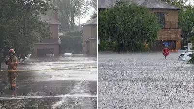
Environment Canada has issued a severe thunderstorm warning for southwestern Ontario, effective immediately. The warning covers a broad region including Kitchener, Waterloo, Cambridge, and surrounding areas. Meteorologists predict the storms could bring damaging wind gusts up to 100 km/h, large hail up to 2 cm in diameter, and torrential rainfall that may cause flash flooding.
Timing and Affected Areas
The storms are expected to develop this afternoon and persist into the evening hours. The warning zone extends from Lake Huron eastward to the Greater Toronto Area, with the most intense activity likely near the Kitchener-Waterloo corridor. Environment Canada advises residents to monitor weather alerts and seek shelter immediately if threatening weather approaches.
Potential Impacts
In addition to strong winds and hail, frequent lightning and heavy downpours are anticipated. Localized flooding in low-lying areas and urban centers is possible due to rapid runoff. Power outages may occur as a result of falling trees or debris. Residents are urged to secure loose outdoor objects, park vehicles under cover, and avoid driving through flooded roads.

According to Environment Canada meteorologist David Phillips, "These storms are typical of late June, but the intensity could be higher due to the heat and humidity. People should take this warning seriously." He emphasized that conditions could change rapidly.
Safety Recommendations
Officials recommend staying indoors away from windows and electrical appliances. If caught outside, avoid open fields, hilltops, and bodies of water. The warning is expected to remain in effect until late evening, after which the system will move eastward. For the latest updates, residents can check Environment Canada's website or local news outlets.